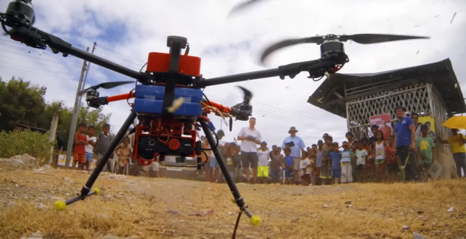
There are 24 million land parcels in the Philippines, and only half of them are titled. People without clearly defined property rights can’t make prudent long-range economic plans, so the Foundation for Economic Freedom, Inc., an Atlas Network partner based in the Philippines, has worked to document Filipino citizens’ property claims with its Technology for Property Rights (TPR) project, which advocates the use of small unmanned aerial systems (SUAS), or “drones,” as a tool for land surveying. Other TPR project partners represent both the private sector (Skyeye, Micro Aerial Projects, and the Asia Foundation) and the public sector (Land Management Bureau, Municipality of Cordova, and the Department of Environment and Natural Resources).
“Participation in the formal land market is one of the biggest obstacles to economic freedom in the Philippines,” said Rene Sanapo, team leader for FEF’s Technology for Property Rights Project. “There are an estimated 10–12 million untitled land parcels. Without titles, people don’t have security of tenure, are not investing in their lands because they fear losing it. That keeps the value of properties down. They are also not able to optimize the use of their lands as collateral, which prevents them from raising the capital needed to make significant personal, family or business investments.”
Before FEF began its reform efforts, roughly only 5,000 new property titles were granted each year. At that rate, it would have taken more than 100 years to document all the untitled land in the Philippines. Thanks to FEF’s efforts, Republic Act No. 10023 passed in 2010, enabling any Filipino citizen who occupies residential land to apply for a “Free Patent Title” for that land. Even under the new act, however, only 50,000 to 60,000 new titles are granted each year. At that pace it will still take far too long to title the millions of parcels that remain.
A significant barrier to acquiring land titles in the Philippines is the difficulty with which subdivision surveys are conducted. These subdivision surveys divide tracts of land into smaller parcels, and are required in order to obtain a land title. The current method of conducting these subdivision surveys, however, is time-intensive and costly.
The TPR project conducted a 10-day pilot study in Cordova, Cebu, to determine whether drones can be used in conducting the subdivision surveys — and whether they could be cost-effective, time-efficient, and compliant with government accuracy standards.
“Currently, subdivision surveys are done using conventional surveying instruments (such as total stations) and global navigation satellite system (GNSS) receivers, or the combination of both,” FEF reports. “However, these instruments are unfavorable in crowded urban settings where subdivision surveys are normally conducted because these tools require point-to-point visibility and enough satellite signal reception.”
Special GNSS receivers and GPS platforms attached to the drones allow land surveys to be conducted with greater precision, and without needing to create ground control points (GCPs). After the drones’ picture-gathering flights are finished, the photographs are processed and incorporated into geographic information system (GIS) programs.
The study determined that drones could cover the same ground in 10 minutes that had previously taken six hours with conventional GCP use. Expanding the use of drones in land surveying could expedite the land titling process throughout the Philippines, and eliminate significant barriers to fuller economic participation.
“We’re helping to remove this obstacle by helping people to get titles to lands,” Sanapo said. “Access to titles is like a table standing on several legs — among these legs are legislation, institutional arrangements, data, and technology. The foundation's work with RA 10023 strengthened the legislation leg; our work on LGU-DENR partnerships is for the institutional leg; and our work with drones enhances the technology leg. By providing new technology for cheaper and faster subdivision surveys we hope to make it easier for Filipinos to get titles to their own lands.”